Houses of Interest: Lincolnshire
The #ECWtravelogue has dipped its toe into Lincolnshire, gateway to the heartlands of the Eastern Association, and the important ports connecting England to the Low Countries. Make yourself a cup of tea and settle back for a story of blue on blue killing, and the use of human shields. Please note that several entries are private residences with little or no public vantage points - they are included for 'completeness'. Do not trespass or irritate their owners please.
At the outbreak of the Wars, Lincolnshire was a divided County, Parliament having slightly more support than the King. Following the 1643 campaign the County was a stronghold of Parliament - not that they had it all their own way. The Royalist strongholds at Newark and Belvoir Castle providing considerable nuisance when the Eastern Association left the County to pursue bigger goals.
There is a memorial to the battle on Foxby Hill.
Parliament's success was short lived as the town fell to a large force led by Newcastle on the 31st July.
Lincoln, is one of England's great medieval cities... so expect lots of medieval, and early modern buildings. Timber frames and jetted buildings are in plentiful supply here. The best place to look is on the appropriately named Steep Hill.
 |
| The Castle Yard |
 |
| Looking down Steep Hill |
At the outbreak of the Wars, Prince Rupert marched into the town and took the town's powder and guns. The Castle had a Royalist garrison, but was besieged by the Earl of Manchester in May 1644. The town fell in a day to Manchester but the Castle, aided by heavy rain, was a harder nut to crack. The first assault got nowhere as the embankments were too slippery because of the rain; the successful assault succeeded despite the scaling ladders being too short, and the castle's defenders raining rocks down upon the attackers. Parliament's men made it over the walls and the defenders quickly capitulated: Parliamentarian casualties were claimed as 8 killed and approximately 40 wounded, the Royalists 50 killed with 100 officers and between 650 and 800 soldiers taken prisoner.
Lincoln Cathedral was for many years England's tallest building, but the spires which earned the cathedral this title, and the title itself are all long since gone. Only recently has the Cathedral been divested of the scaffolding that have shrouded it for several decades. It has been beautifully restored and cleaned.
The Cathedral was despoiled by Parliamentarian soldiers who most notably smashed up the tombs of Eleanor of Aquitane's (the brass effigy is a Victorian replacement) and Katherine Swynford (John of Gaunt's third wife, her tomb is unrestored).
Both can be found in St John the Baptist's Chapel: Swynford's is on the left, Eleanor of Aquitane's on the right (the Lincoln Imp is also in this area, look up and to the right of the Chapel, above a bearded man's head).
 |
| The Victorian Gaol |
Lincoln Castle is unusual in that it has two mottes. It is free to enter, but there is an entrance fee to the gaol and the wall walk. The wall walk is well worth the effort of trying to get the turnstile scanner to scan your ticket's bar code.
 |
| The Observatory Tower |
 |
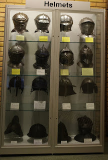
| Armour on display at the Collection |
Lincoln's museum, The Collection, has a small Civil War display, be wary of the robot guides (yes really), as well as some stunning Roman, Anglo-Saxon and medieval displays.
 |
| Torksey Castle |
Torksey Castle isn't really a castle, it was a Tudor manor house. Located on the banks of the Trent, the castle guarded a crossing of the Foss Dyke located to the south of the house. Briefly garrisoned by the Royalists in 1644; Parliament's men took the garrison by surprise in August 1645 using scaling ladders. They took 140 prisoners before setting light to the place. The ruins of the castle's frontage has been stabilised by English Heritage but it can not be visited. In fact it is pretty difficult to get any view of the place at all (Lincoln Art Gallery have a painting of it in their collection, sadly not currently on display).
 |
| Doddington Hall |
Located to the west of Lincoln is Doddington Hall home to the Hussey family; John Hussey's buff coat and breastplate, helmet, boots and gloves are on display - "the Doddington Armour".
According to the 'story' twenty six year old John fell at Gainsborough slain by a musket ball which clipped the top of his cuirass, and went through his buff coat.
 |
| Musket ball entry clearly visible |
John was, so it is claimed, a cavalry officer in the King's Army.
Firstly let's look at his uniform: the buff coat is a short, grand affair; sleeves are sewn rather than laced, and have rows of what look like decorative button holes sewn into them. This looks to be a fairly fancy buff coat. The armour and helmet, in particular, look to be older than the Civil Wars - was John given hand me down 'uniform'? Without the given back story I would have guessed that he had been an officer in a Regiment of Foot rather than in a Regiment of Horse, 'hand me down uniform' could explain this away. But the tassets are still troubling - it wouldn't have cost a great deal, or been too difficult for a local blacksmith (rather than an armourer) to remove them. Wearing tassets would make riding a horse very uncomfortable at best, or impossible depending upon how well the hinges work.
We don't know the exact circumstance of John's mortal blow. We do know that the Royalist Horse were cut down in the bog close to the Trent. The fatal shot was fired either on a level or looking down upon John. Both of which would be pretty unlikely if he was astride a horse. Had he been unhorsed? Or was he never on horseback in the first place? Those tassets make me wonder.
And finally, in what Regiment did he serve? Only two Husseys appear in Reid's collated Cavalier Army List: James a captain in Ashburnham's Foot, who fought almost exclusively in the West Country; and John who was a captain in Henry Cromwell's Horse (yes Henry was Oliver's cousin, so not at all awkward!) who we know precious little about.
 |
| John Hussey |
We do know of a petition by Sir Charles Hussey's daughters (from Doddington Hall) who "was in armes against the Parliament and dyed a delinquent", fought in either Sir Peregrine Bertie’s Regiment of Horse or Sir Robert Dallison’s Regiment of Horse. Both Regiments were Lincolnshire based, Dallison's are believed to have fought at Gainsborough. Was John a son of Charles, or a nephew? I have been unable to trace John in Charles's direct family tree. Charles was an important local dignitary, it wouldn't take too much of a stretch of the imagination for him to wangle a junior commission for a relative such as his nephew.
Now for another battle...
In 1643 Newcastle was besieging the Parliamentarian stronghold of Hull, Fairfax's horse were ferried across the Humber into Lincolnshire where they met with forces under the command of rising star Colonel Oliver Cromwell. This force would go on to besiege Bolingbroke Castle. Newcastle ordered Sir William Widdrington to take a small force of cavalry and dragoons from Lincoln to confront this force and relieve the garrison.
On the night of the 10th October Widdrington's men met a detachment of Parliamentarian cavalry at Horncastle, after a short exchange of shot, Parliament's men withdrew. Armed with the news that Widdrington was advancing a small force of men blocked Bolingbroke Castle whilst the bulk of the Parliamentarian forces marched north to meet the Royalist threat. The cavalry from both sides would meet for a short but bloody battle in Winceby on the 11th October 1643. The battle was a convincing win for the Cromwell led cavalry: Cromwell's men quickly routing the Royalist horse who tried to flee towards Horncastle. Their retreat was blocked by a gate that opened towards them, the weight and number of their men fleeing stopped them opening the gate and they were cut down. Cromwell's men killed 2-300 Royalists and captured 800 men, for the claimed loss of just 20 of their own men.
The true location of the battle is disputed - Historic England places it to the north of Slash Lane, Glen Foard puts the action more to the south of Slash Lane. All of the locations described below are on, or very close to Slash Lane (with the one exception).
In case you are wondering, local tradition tells us that Slash Lane is so called because of the bloodshed spilled along its route - the route being the course the Royalists fled along.
There is a battlefield memorial located on the main road outside Winceby House Farm, close to the turning for Old Bolingbroke and Asgarby (almost opposite the Winceby village sign at the east of the village).
There are three battlefield information boards, one is located in what was once the car park for Snipe Dales Nature Reserve (there is still a brown tourist road sign for the car park, the car park is/was the first gate on your left after this sign heading east).
 |
| The main 'layby' interpretation board, and the very large rock |
The main information board is located in the layby heading westwards towards the A158 (those of you heading east from the A158 it is the second layby on your left) - keep a look out for a very large rock adjacent to the information board.
The final board is located south of Winceby on the Chapel Road close to Hameringham (heading south along Chapel Road you will pass a mobile phone mast on your right, a few hundred metres further on there is a copse on the right and a footpath finger post on the left, this is where the information board is located - blink and you'll miss it).
St Mary's Church in Horncastle has a memorial to Sir Ingram Hopton; Hopton allegedly shot a horse from under Cromwell, but was himself slain during the battle (the memorial describes Cromwell as an 'arch rebel', and bears an incorrect date for the battle - 6th October).
Crowland Abbey and the village of Crowland were fortified by the Royalists in 1643; they were besieged, surrendering after three days of bombardment in April 1643. When the Royalists heard that Parliament was coming to besiege the Abbey, and town they took four pro-Parliamentarian hostages who they tied to stakes positioned upon the ramparts, effectively using them as a human shield.
Parliament's men didn't hold it for long they left the Abbey, and the Royalists happily garrisoned it again. Fairfax would attempt to besiege it in 1644, but flooding hindered his attempts; the flooding that hindered Fairfax, also stopped the Royalists taking in supplies, they would surrender due to starvation by the end of 1644.
The ruins of the Abbey have been incorporated into a smaller church. The thatched cottage opposite the entrance to the Abbey grounds dates from before the Civil Wars.
The private house, Cressey Hall was briefly garrisoned by Parliament during 1643.
St James Church in Woolsthorpe is a Victorian church built upon the site of a much older church that was significantly damaged by cannon fire during the siege of Belvoir Castle. The Parliamentarian forces that took the church and village spent the night in the village, stabling their horses in the church. In the morning they set light to straw inside the church burning it down.
South Kelsey Hall was a moated manor house that was fortified by its owner, Sir Edward Aysough. There are some earthworks present that are likely to have been a gun battery placement. The site is now a farm and private houses. Neither the remains of the moat or the earthworks are visible from public vantage points.
The bridge over the River Steeping at Wainfleet All Saints was fortified by the Royalists in an attempt to isolate Boston. In October 1643 the defenders heard of an advance by Parliamentarians towards their position, so decided upon discretion rather than valour and fled. No remains of their defensive earthworks are visible sadly.
Tattershall Castle was the home of the 3rd Earl of Lincolnshire; the Earl was a prominent Protestant and declared for Parliament in 1642. The Castle was reinforced and garrisoned. In the summer of 1643 Newcastle's Army advanced into Lincolnshire and took the castle, leaving only the Great Tower intact. After the Kings defeat Parliament ordered the demolition of the entire castle. The Earl of Lincoln appealed to Parliament to leave the Great Tower intact and due to his repeated pleas the demolition order was overlooked.
Kettlethorpe Hall was held by Parliament, the moated hall had its defences improved with substantial earthworks which may have housed a gun battery. The hall is now a farm and private housing - none of which is visible from public access vantage points.
Where the Rivers Trent and Ouse meet to form the Humber Estuary is a parcel of land called Alkborough Flats, a low-lying flood plain overlooking the rivers. An ideal site for a gun battery to command entry into both the Trent and Ouse. In 1643, the Eastern Association defeated the Royalist troops stationed there. The area is an important site for wading birds, so if you do take your dog with you please make sure it is on a lead. To find the site, it is best to download the Alkborough Heritage Trail leaflet, park in Alkborough (West Halton Lane seems ideal) and follow the footpaths marked upon the heritage trail leaflet to the site.
Mablethorpe Hall was garrisoned by the King's men, earthworks were constructed to defend the former hall; in 1922 these were said to be still visible. The Hall would fall to Parliament in late 1643. There is no public access to the site, however a better vantage point can be found up the unmade road east of the old petrol station (currently operating as a car wash).
 |
| The Bull and Swan, Stamford |
Stamford, despite being strategically placed upon the Great North Road the Wars pretty much passed the town by. Briefly occupied by Royalist horse from nearby Belvoir Castle in July 1643, and again in October 1644. There is no evidence of their presence, even the ruins of Stamford Castle are possibly in better shape now than they were in the C17th. If passing through Stamford, parts of the Bull and Swan date from the mid C16th, and several residential buildings in the town, will have witnessed the fighting.
“Out of Lincolnshire the Relation is come, that the Newarke Cavaliers with strong forces, were gotten into Burleigh House neer Stamford… But Colonell Cromwell being unwilling that they should nestle there, with all the strength he could get, came upon them, tookethe said House, and in it two Colonells, sixe Captaines, four hundred foote, and two hundred horse…”
 |
Grantham was taken in March 1643, by a large force of Royalists from Newark commanded by Sir Charles Cavendish and Sir John Henderson. The Royalists did not garrison Grantham but continued on towards Boston meeting, beating a Parliamentarian force at Ancaster Heath on the 11th of April, before their passage was halted by Cromwell at Belton on the 13th of May.
 |
| St Wulfram's, Grantham |
Alas there are no visible scars or commemorative plaques pertaining to any of these engagements. A number of buildings that witnessed the events still stand in Grantham (C10th St Wulfram's and on the opposite side of the road the C14th Grantham House) and Ancaster (St Martin's Church, and its next door neighbour Ancaster Hall being the most notable). The site of the action at Belton is not certain, but is most likely to have taken place in what is now the deer park of Belton House which was built in the 1680s.
 |
| Grimsthorpe Castle |
Grimsthorpe Castle was garrisoned by the Earl of Lindsey in 1643, it would fall to the Earl of Manchester in early 1644. The Castle was rebuilt in the C18th, it opens to visitors in the during the summer.
Postcodes for SatNavs
Foxby Hill, Gainsborough DN21 1PNKerry Foods (Candish Bog) DN21 1LG
Lincoln Castle, Castle Square LN1 3AA
The Collection, Danes Terrace LN2 1LP





Just stumbled upon your fantastic blog. Thank you so much for this content. I am currently researching and planning a 15mm ECW wargaming project and find your blog a truly valuable source of inspiration and information. As an ex-pat from Northumberland now living in Nova Scotia, Canada, I love seeing all of the on location posts. Eagerly following!
ReplyDeleteThank you for your kind words Alex.
DeletePlease note that I take no responsibility for denting your wallet. (And apologies for not having written the Northumbria travelogue page yet.)
There was also a minor action at Barton upon Humber in 1643 following the Fairfax’s defeats at Adwalton Moor and Selby. Sir Thomas took the cavalry south of the Humber while the rest of the army retired to Hull along the north bank. There was a delaying action just East of Barton possibly inside the modern town’s fringes. The town has two churches one (St Peter’s has an Anglo Saxon tower) the other (St Mary’s) has civil war inscriptions scratched in the font by prisoners who were held in the church.
ReplyDeleteMany thanks - I'll have to visit and add it to the entry.
Delete